What's Happening Archive
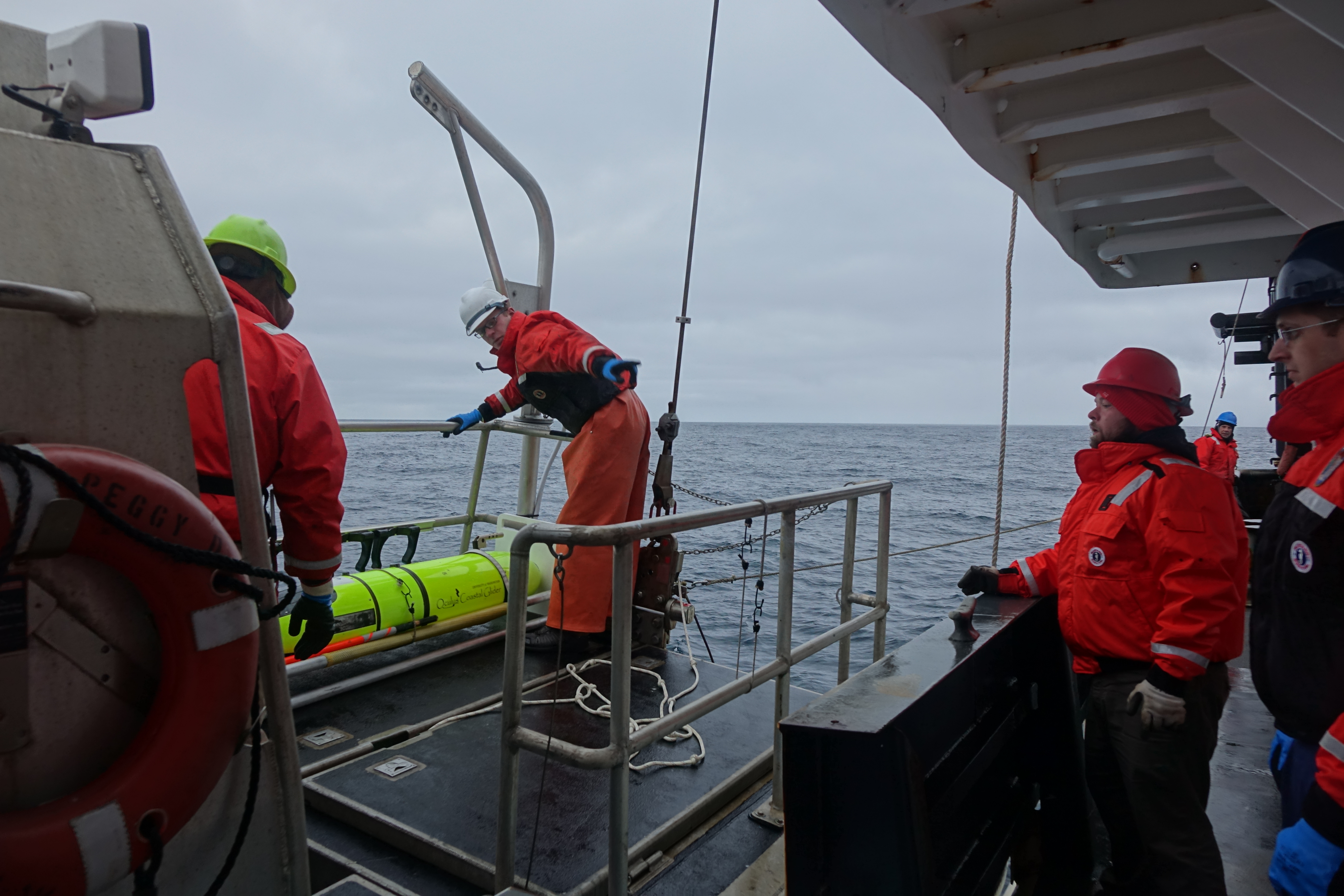
Oculus Coastal Glider being recovered by the crew of the NOAA Ship Oscar Dyson.
After 60 days in the Bering Sea, the Oculus Coastal Glider was successfully recovered by crew of the NOAA Ship Oscar Dyson on September 26, 2017. The glider successfully navigated 242.8 nautical miles, completed 3612 dives, and sampled salinity, temperature, dissolved oxygen, sunlight, and fluorescence at a frequency of approximately 3 dives per hour. The glider was tested in a region with a long history of shipboard and mooring observations that provide context for the Oculus glider's observations. Oculus glider measurements reveal detailed information in a known, important biogeographical transition that divides the ecosystems of the northern and southern Bering Sea shelf near St. Matthew Island. Measurements show unexpected ocean mixing in the water column near the island that may be due to internal waves. Data, sensor, and platform analysis is ongoing. Incorporating this higher resolution sampling into the Bering Sea observing network will improve our understanding of how these features affect the ecosystem.
The Oculus is a coastal glider engineered to work in the highly stratified, shallow depths of the Arctic. By using a rapid buoyancy system, the glider can change buoyancy states 20 times faster and achieve speeds three times faster than legacy gliders - allowing for a more efficient and adaptive Arctic survey, but transferable to a variety of markets.
This was the second field test for the Oculus coastal gliders. The first field test occurred early May 2017, also in the Bering Sea, with 387 dives completed near the M2 mooring site. For the second field test, the glider was deployed from the US Coast Gaurd Cutter Healy during the 2017 Arctic Shield mission.
The Oculus was developed at PMEL in partnership with the University of Washington's Joint Institute for the Study of the Atmosphere and Ocean and the University of Washington Seaglider Fabrication Lab.
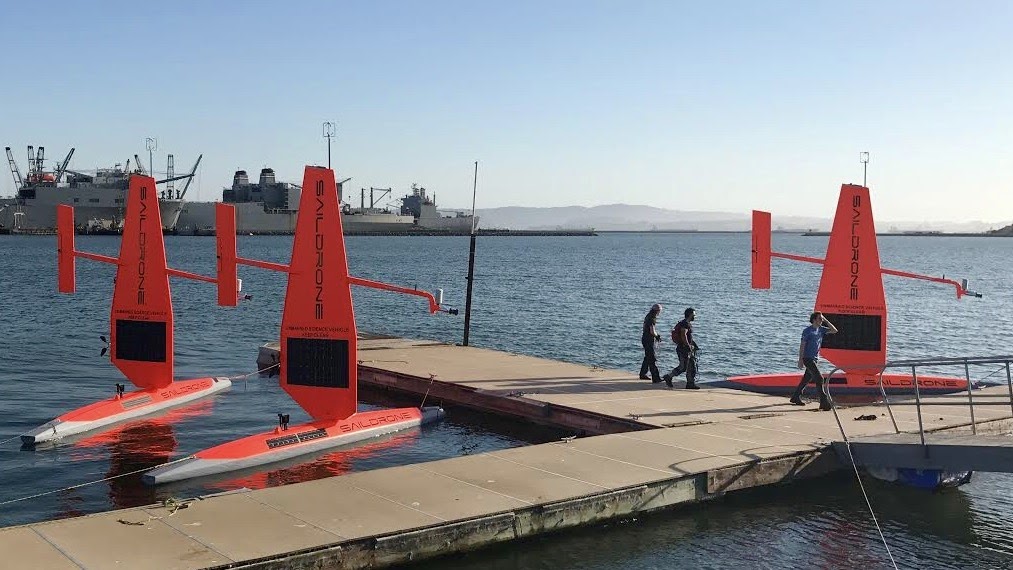
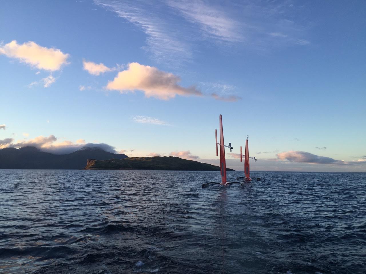
The fleet of saildrones pictured here are being prepared for a summer and fall of science from the Bering Sea to the Arctic to the far reaches of the tropical Pacific Ocean. Credit: Saildrone Inc.
Over the next four months, NOAA scientists will launch unmanned ocean vehicles, called Saildrones, from the Arctic to the tropical Pacific Ocean to help better understand how changes in the ocean are affecting weather, climate, fisheries and marine mammals. The wind and solar-powered research vehicles that resemble a sailboat will travel thousands of miles across the ocean, reaching some areas never before surveyed with such specialized technology.
Earlier this week, PMEL scientists and Saildrone, Inc. sent off three saildrones from Dutch Harbor, Alaska. For the first time, two saildrones will sail north through the Bering Strait into the Arctic Ocean to study how the Arctic Ocean is absorbing carbon dioxide. A third unmanned vehicle will survey more than 3,100 nautical miles in the Bering Sea for walleye pollock, Northern fur seals that prey on them and the elusive North Pacific right whale. This work will build on research conducted during 2016, including a study of fur seal feeding rates. NOAA Fisheries Alaska Fisheries Science Center scientists will also attach video cameras to fur seals to record feeding and verify the species and sizes of fish that fur seals are eating.
In September, scientists will launch two more unmanned systems from Alameda, Calif., on a six-month, 8,000-nautical-mile, round-trip mission to the equator to improve the Tropical Pacific Observing System (TPOS). TPOS provides real-time data used by the U.S. and partner nations to forecast weather and climate, including El Nino. The unmanned sailing vehicles will take part in a larger field study with NASA, and visit mooring sites along the array of observing buoys.
Read the release on NOAA Research here and follow along with the Innovative Technology for Arctic Exploration's Blog for the Bering and Chukchi Seas missions.
The EcoFOCI spring mooring cruise departed on Earth Day, April 22, from Kodiak, AK to service a biophysical mooring array in the Bering Sea, including M2. This is one of 11 research cruises the program will participate in from March-October. Aboard the NOAA research ship Oscar Dyson, scientists from PMEL, JISAO and AFSC are in Alaskan waters to retrieve and redeploy moorings, collect CTD (conductivity-temperature-depth) and other data. Peter Proctor from PMEL/JISAO is the Chief Scientist on the cruise and Geoff Lebon is the lead mooring scientist. The M2 mooring has been deployed in the southeastern Bering Sea for over 20 years and has been providing year-round measurements of temperature, salinity, nitrite, chlorophyll, and currents in this highly productive area. Long-term time-series at this site are a critical tool for adapting to climate change and guiding sustainable management of living resources in the Bering Sea.
EcoFOCI will also be field testing and using several technologies in collaboration with PMEL’s Innovative Technology for Arctic Exploration program; including the Prawler, Oculus and Acrobat Towed Vehicle. These technologies enhance shipboard and mooring research with more data collection over a fine scale region.
The EcoFOCI program is a collaborative research effort by scientists at the Pacific Marine Environmental Lab (PMEL) and Alaska Fisheries Science Center (AFSC) focusing on the unique and economically important high-latitude ecosystems of Alaska. Learn more about the program here.
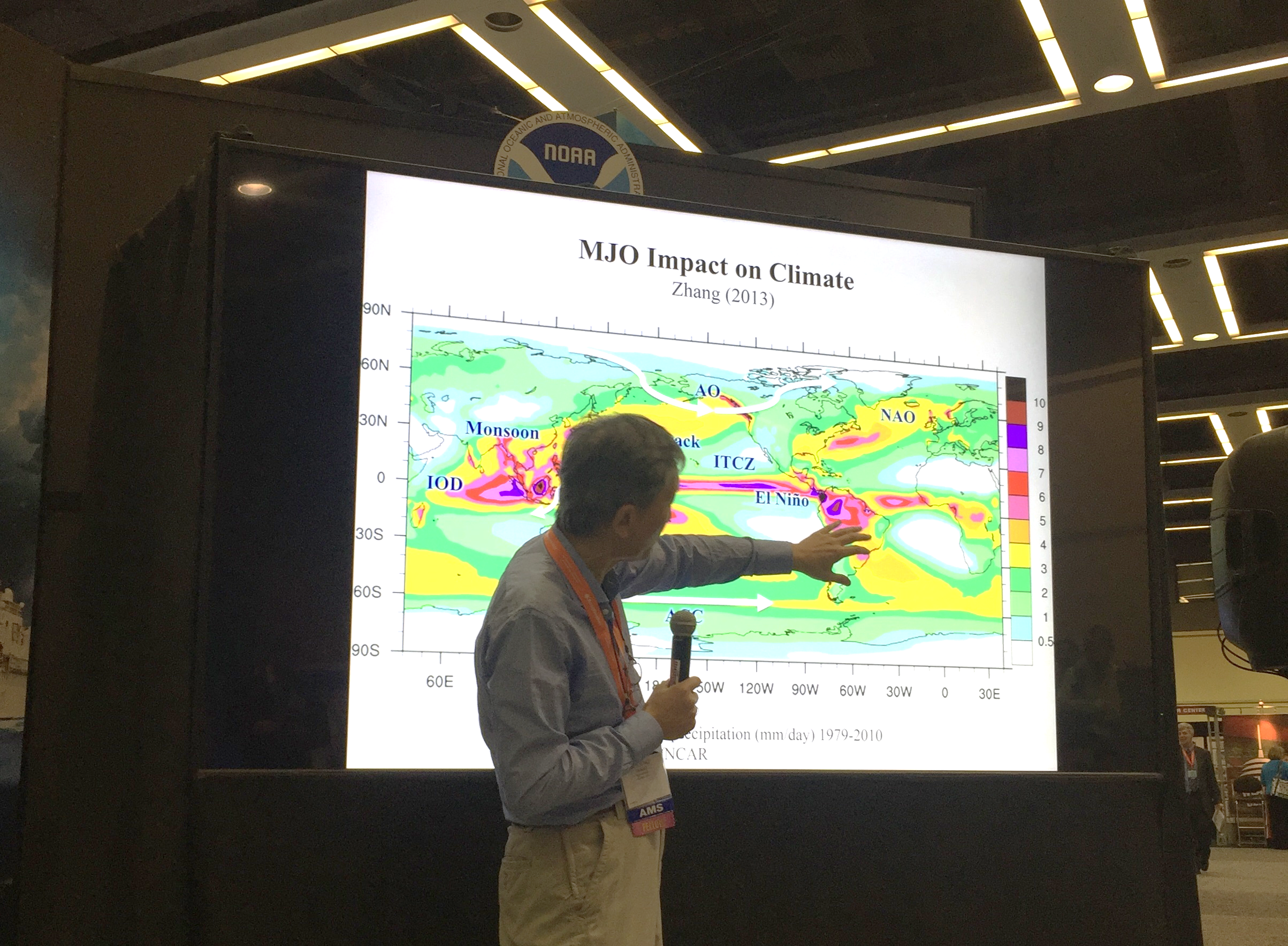
Dr. Chidong Zhang gave a talk at the NOAA Booth during AMS about his research on the Madden Julian Oscillation.
Last week, PMEL scientists attended the American Meteorological Society (AMS)’s Annual Meeting in Seattle, WA and the Alaska Marine Science Symposium (AMSS) in Anchorage, AK. Presentations covered research in the Bering Sea, data management and access, El Nino, sea ice, the Earth's energy imbalance, innovative technologies, and recent warming in the Pacific and others.
At AMSS, the Ecosystems and Fisheries-Oceanography Coordinated Investigations (EcoFOCI) group had multiple presentations and posters on the Bering Sea including topics on the recent marine heat wave in Alaska, linking annual oceanographic processes to contiguous ecological domains in the pacific Arctic, fish distributions, ecology, Saildrone and oceanography.
A wider range of topics were covered at AMS and included invited talks from Nick Bond, Chidong Zhang and Kevin Wood. Dr. Zhang spoke about the Dynamics of the Madden-Julian Oscillation; Kevin Wood presented the Old Weather Project using historical U.S. ship logbooks to collect and analyze historical climate data; and Nick Bond discussed the recent warming in the NE Pacific. The annual meeting is the world’s largest yearly gathering for the weather, water, and climate community and brings together atmospheric scientists, professionals, students, educators and research’s from around the world. AMS is the nation’s premier scientific and professional organization promoting and disseminating information about the atmospheric, oceanic, hydrologic sciences.
Learn more about all our different research themes and groups here.
NOAA Fisheries and its partners, including the Pacific Marine Environmental Laboratory, released Regional Action Plans (RAPs) on December 16th, to guide implementation of the NOAA Fisheries Climate Science Strategy in each region (Northeast, Southeast, Gulf of Mexico, Alaska, Western, Pacific Islands). Ecosystems and Fisheries Oceanography Coordinated Investigations (EcoFOCI) program lead Phyllis Stabeno (PMEL) and Janet Duffy-Anderson (AFSC) were co-authors on the Alaska Regional Report. The Alaska Fisheries Science Center and the Pacific Marine Environmental Laboratory have the scientific infrastructure needed to produce the analyses and deliver benchmarks for the eastern Bering Sea.
This Regional Action Plan identifies key actions to address priority information needs over the next five years to better understand, prepare for and respond to climate changes in the Bering Sea ecosystem. The Regional Action Plan, part of the NOAA Fisheries Climate Science Strategy, focuses on seven science objectives.
Alaska's fisheries are worth $1.8 billion and are vital to local economies and our country's food supply. Alaska is also at the front lines of a changing marine environment. To protect and maintain the region's resources, fishermen, lawmakers and other decision-makers need information to respond to these changes and protect livelihoods and traditional cultures.The Regional Action Plan will help Alaskan communities, commercial and recreational fishermen and others who are dependent on Alaskan marine resources respond and adapt to changes that may be ahead in response to a changing climate and help ensure the sustainability of these marine resources.
Read plan highlights here.
Read the full report in the NOAA Fisheries scientific publication, Technical Memorandum.
Learn about Regional Action Plans from across the country, here.

Poster Hall at the Fall Meeting. There were approximately 24,000 attendees in 2015. (Photo Credit: AGU)
PMEL scientists, including scientists from the University of Washington's Joint Institute for the Study of the Ocean and Atmosphere (JISAO) and Oregon State University's Cooperative Institute for Marine Resources Studies (CIMRS) are attending the American Geophysical Union (AGU)’s Annual Meeting in San Francisco this week, December 12-16. AGU's Falling Meeting is the largest Earth and space science meeting in the world bringing together the Earth and space science community for discussions of emerging trends and the latest research. Poster and talk topics include data integration, El Nino Southern Oscillation (ENSO), Indian Ocean temperature trends, hydrothermal plumes and vents, carbon dioxide in the tropics and Gulf of Alaska, aerosol research, and heat impacts on marine ecosystems and fisheries, tsunamis, and acoustic research.
The 2016 Arctic Report Card will be released Tuesday morning in conjunction with a press conference led by NOAA’s Jeremy Mathis. The 2016 Arctic Report Card brings together the work of 61 scientists from 11 nations to provide the latest information on multiple measures of Arctic environmental change, including air and sea surface temperature, sea ice, snow cover, vegetation, wildlife, and plankton abundance. Read the full report and highlights here as well as the press release. Watch the recorded press conference here.
Researchers will also present during a press conference Thursday morning some of the first scientific results from the 2015 Axial Seamount eruption including discoveries of previously unknown structures and new glimpses into the volcano’s internal plumbing. These new insights into the world’s most active and well-studied underwater volcano may help scientists better understand all volcanoes and the hazards they pose. Read the press release here. Watched the recorded press conference here.
Dr. Bob Embley from the Earth-Ocean Interactions group will be honored during the Awards Ceremony as part of the 2016 class of Fellows for his pioneering contributions to the understanding of deep-sea volcanism by fostering interdisciplinary investigations with advanced technologies.
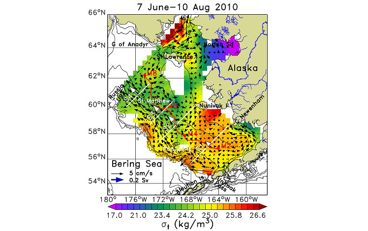
This map shows the water density (σt = density–1000 kg/m3) and surface currents (black arrows) on the eastern Bering Sea continental shelf as determined from measurements of the ocean temperature and salinity. White arrows show the total transport (1 Sv=106 m3/s) of water across sections S1-S4.
In the summers of 2008–2010, Dr. Ned Cokelet added rugged instruments to NOAA bottom trawl survey nets on the eastern Bering Sea continental shelf – site of the nation’s most productive fisheries – to measure ocean temperature and salinity at over 350 locations. The results, released in Deep Sea Research II, provide the most comprehensive view to date of the three-dimensional thermohaline structure. Horizontal variations of the ocean’s mass density, computed from the temperature and salinity measurements, give the ocean currents shown by arrows in the accompanying figure for summer 2010. The flow was strongest west of the Pribilof and St. Matthew Islands, and there was clockwise circulation around St. Matthew Island. The upper layer of the ocean was mixed down to less than 30 m over much of the region, but reached depths greater than 70 m along the Alaska Peninsula. Upper-to-lower layer salinity differences contributed more than temperature to density differences over most of the region. These observations enhance our understanding of plankton and fish-larval transport and can serve to calibrate predictive computer models of the ecosystem.
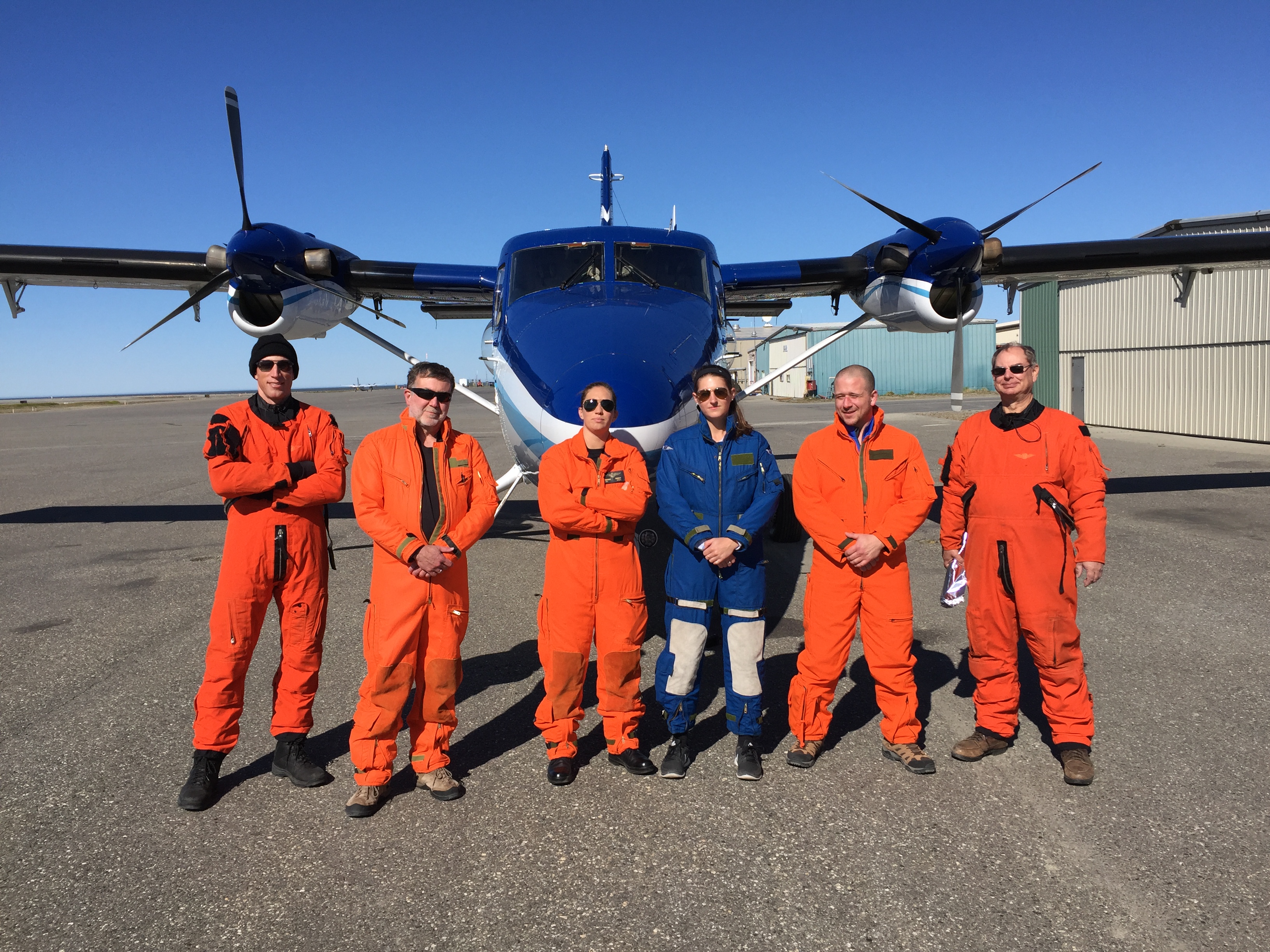
The PMEL Arctic Heat research team, including cooperative institute (JISAO) scientists, in front of NOAA Twin Otter during the first flight in June. From left to right: LT Alex Johnston, co-pilot; Dr Kevin Wood, lead scientist; LT Shanae Coker, aircraft commander; Leah Chomiak, Hollings Scholar; Alex Ekholm, WHOI engineer; Jeff Smith, scientific systems engineer.
September 10 – 20: The Arctic Heat Team has been making their way from Barrow, AK to Kotzebue on a specially-outfitted NOAA Twin Otter aircraft. Over the 10 day mission, the team is launching traditional atmospheric and oceanographic probes as well as the experimental Air-Launched Autonomous Micro-Observer (ALAMO) floats into the Chukchi Sea. Four ALAMO floats were deployed in June 2016 in the Chukchi and Beaufort Seas. These floats will continue to collect data on upper ocean temperatures throughout the year.
The team on this mission includes: Kevin Wood and Nick Bond from UW/JISAO and NOAA/PMEL, Woods Hole Oceanographic Institution’s engineer Alex Ekholm, and LTJG Kevin Doremus as the Aircraft Commander.
Watch a video of the team launching various floats during the first deployments on YouTube.
The saildrones as they make their way to Dutch Harbor, AK for recovery. Photo Credit: Saildrone, Inc.
On September 3, after three months of collecting data in the Bering Sea, the two Saildrones have been safely recovered. The Saildrones each traveled almost 3000 nautical miles in 101 days. After arriving in Dutch Harbor, AK, the Saildrones were packed into a container and shipped to their home base in San Francisco, CA. Data from the tested technologies for fish and marine mammal acoustics are expected mid-September with preliminary analysis completed around the New Year.
This was a collaborative mission between the Pacific Marine Environmental Lab, Alaska Fisheries Science Center, Saildrone, Inc., Simrad AS/Kongsberg Maritime, Greeneridge Sciences, Inc, and Wildlife Computers.
Continue to follow the Saildrone on the Innovative Technology for Arctic Exploration page to learn more about upcoming events and preliminary results in the weeks and months to come.
Principal investigators at the Arctic IERP meeting in Anchorage, AL.
PMEL scientists from the Ecosystems and Fisheries Oceanography Coordinated Investigations (EcoFOCI) program attended the first Principal Investigator meeting for the North Pacific Research Board (NPRB)’s five-year Arctic Integrated Ecosystem Research Program (Arctic IERP) in Anchorage, Alaska on June 20-23.
This historic Arctic Integrated Ecosystem Research Program will study the northern Bering and Chukchi Seas during spring through fall to better understand how changes in physical environmental drivers influence the structure and function of the biological system and access to subsistence resources. The EcoFOCI team (comprised of PMEL, AFSC, JISAO, and Bigelow Laboratory scientists) will lead the Oceanography and Lower Trophic Level Productivity portion of the program under the direction of Carol Ladd. The field seasons for this project are planned to begin in spring 2017 through the fall of 2019.
The goals of the meeting were to introduce the funded projects, discuss how these projects are connected, identify any gaps, come to a consensus on the overarching hypothesis for the integrated research, introduce PI's from other Arctic projects that may integrate with the Arctic IERP research, and discuss the framework for integration, data management, and communication/outreach during the project.