What's Happening Archive

NOAA's Oscar Dyson conducting a research cruise in the Arctic Ocean. Credit: Carl Rhodes
Understanding how Alaska's vast marine ecosystems are changing requires long, consistent records — something scientists have rarely had access to in one place. Now, NOAA and CICOES scientists have released a public dataset that compiles nearly five decades of ocean observations into a single, accessible product.
Designed to support climate research, ecosystem modeling, and machine-learning applications, the Alaska Compendium of Ocean Profile Data, or ACOD, offers a single point of access to 47 years of hydrographic and nutrient sampling.
"By bringing together nearly 50 years of oceanographic observations into one resource, ACOD represents a huge step toward reducing data fragmentation and making it easier for scientists and managers to understand long-term ocean changes in Alaska," said co-author Phyllis Stabeno, a physical oceanographer at NOAA's Pacific Marine Environmental Laboratory.
ACOD is host to an enormous amount of data. It includes 29,717 vertical profiles of temperature and salinity from 495 cruises conducted between 1974 and 2021, along with 7,016 nutrient profiles representing over 45,000 water samples collected between 2001 and 2021. These data span the Chukchi Sea, Bering Sea, and Gulf of Alaska, and were collected by a wide variety of NOAA research programs including Ecosystems and Fisheries-Oceanography Coordinated Investigations, or EcoFOCI.
"The EcoFOCI sampling contained in this collection is equivalent to more than 16 continuous years at sea, with more than 7 million meters of profiles, which is actually enough to reach past the center of the Earth," said lead author Calvin Mordy, a CICOES oceanographer.
A major step forward
Until now, scientists studying Alaska waters often had to piece together data from that wide variety of NOAA research programs, which were scattered across an even larger assortment of research products, each with its own formats and quirks. ACOD addresses this by providing standardized formatting, rigorous quality control, and secondary variables such as bottom depth, mixed layer depth, and regional categories. While ACOD does not incorporate all possible variables from all possible data sources — particularly from data sources with no EcoFOCI affiliation — it does represent a major step forward in data accessibility.
"We used an early version of this compilation to validate coupled physical-biogeochemical models, and its consistency and completeness dramatically improved our ability to reproduce observed conditions," said Kelly Kearney, an oceanographer at NOAA's Alaska Fisheries Science Center who was not involved in ACOD's development. "This makes it possible to more effectively evaluate climatological conditions, vertical nutrient structure, and mixed layer depth across decades, which is critical for both ecosystem forecasting and machine-learning approaches."
As Kearney noted, ACOD is particularly valuable for model validation. Its nutrient database also offers potential for AI-driven statistical modeling and extrapolation in data-sparse regions. Future updates are planned to add oxygen, chlorophyll, and other variables, which will only serve to increase its functionality as a training and validation tool for AI products.
Good science, quickly

"The idea is to enable good science, quickly, "said second author Noel Pelland, a CICOES research scientist who served as the technical lead in ACOD's development. "Having datasets like this, that are one-click access, and cover decades — it's hard to overstate how much of a multiplier that can be."
In fact, Pelland mentioned that he and his colleagues have already taken advantage of ACOD to map out historical relationships between nutrients and winds on the Bering Shelf, which is the subject of a recent publication.
Pelland added, "As an observational scientist, I can think of a million sandbox ideas that would benefit from ACOD. And there have also been many projects in the past where we've run up against the limitation of not having access to something like this."
By bringing decades of observations together in a single, open resource, the Alaska Compendium of Ocean Profile Data aims to ease those constraints. Scientists should now encounter the problem of data scarcity less often, helping to accelerate research in one of the nation's most important marine regions — research that has tangible impacts on everyone whose lives and livelihoods depend on healthy, sustainable fisheries in Alaska waters.
By Heather Tabisola with contributions by Joe Selmont. Story originally posted at UW CICOES.
--------
The Alaska Compendium of Ocean Profile Data was built by a team of 11 CICOES and NOAA scientists, including Calvin Mordy, Noel Pelland, Shaun Bell, Wei Cheng, Jeanette Gann, Albert Hermann, Caitlyn McFarland, Jens Nielsen, Phyllis Stabeno, Margaret Sullivan, and Eric Wisegarver.
ACOD is archived on the Dryad open-data publishing platform, where it is preserved with version control and available in NetCDF and CSV formats. It is intended to be updated annually or biennially in coordination with ongoing sampling by NOAA’s EcoFOCI group, as well as the continued rescue and curation of older records. Researchers and the public can access ACOD via Dryad at https://doi.org/10.5061/dryad.gf1vhhn0t.
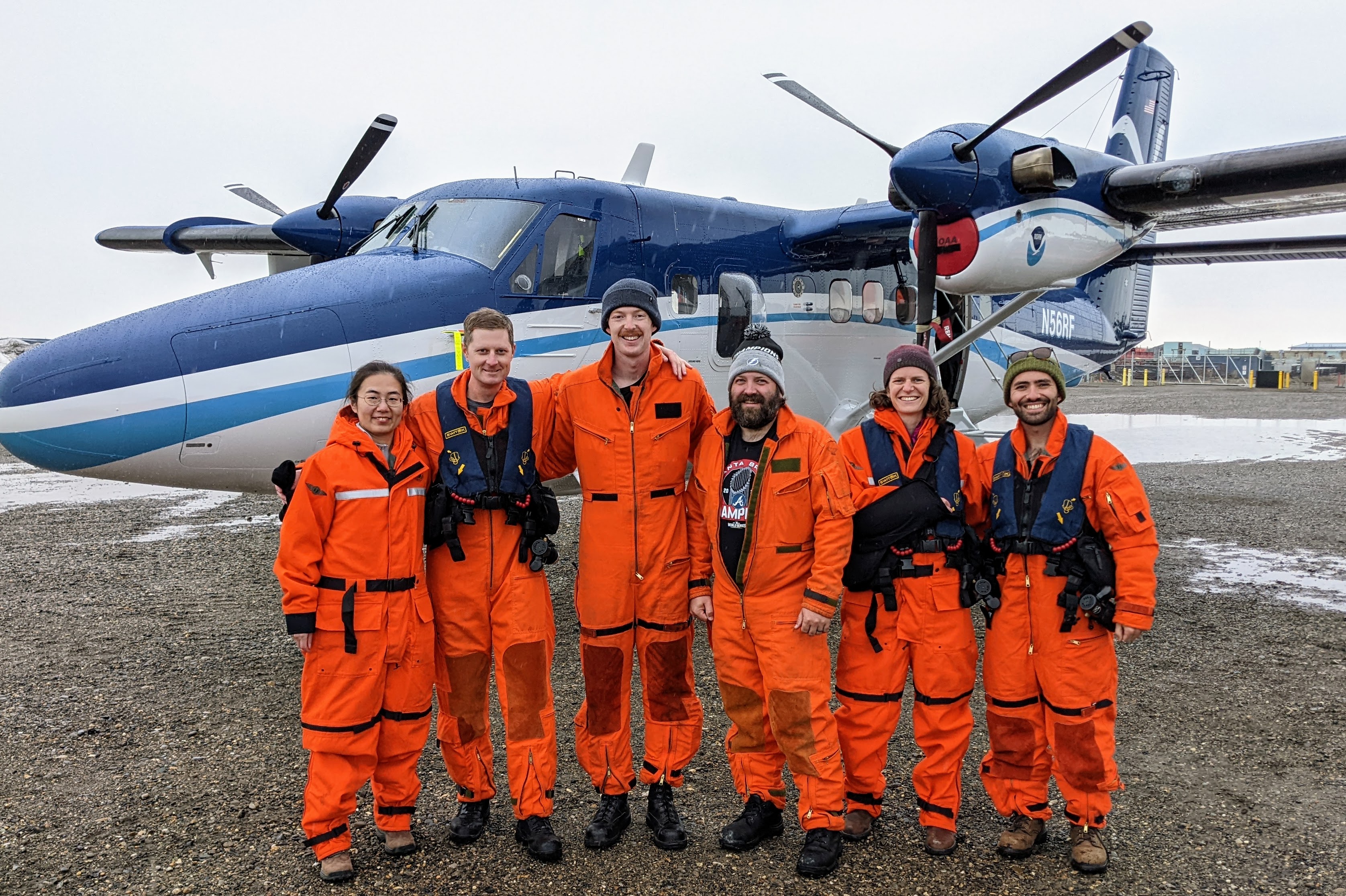
The 2023 June Arctic Airborne Investigations and Research crew consisted of staff from NOAA's Pacific Marine Environmental Laboratory, NOAA Office of Marine and Aviation Operations and University of Washington. They flew over the Southern and Central Chukchi Sea and coordinated overflights with R/V Sikuliaq.
From left to right: Denise Miller (OMAO), Sarah Cozart (OMAO), Nicholas Underwood (OMAO), Jiaxu Zhang (UW/CICOES and NOAA PMEL), Michael Steele (UW/APL), and Zheng Liu (UW/APL). Photo credit: Brent Schoumaker (OMAO)
NOAA and partner scientists recently completed two successful field tests in the US Arctic merging new technologies and traditional ship surveys to assess real-time phytoplankton species distributions in response to surface warming.
The rapid warming of the Arctic Ocean has led to earlier sea ice retreats in spring and later arrivals in fall. This shift has prompted significant changes in phytoplankton communities, which is a critical measurement to understand ecosystem health.
In June 2023, 60 nautical miles of flights were coordinated with a research ship operating in the survey region to use a multispectral camera, the first of its kind. This provided an opportunity for scientists to distinguish phytoplankton species and physical characteristics in the Chukchi Sea.
The team from NOAA and the University of Washington tested a cutting-edge imaging system, to observe distributions of phytoplankton from the NOAA Twin Otter using a hyperspectral camera. The camera uses a sensor that takes many pixelated images that translate to an absorption spectrum based on the colors the phytoplankton reflects. The hyperspectral camera uses reflectiveness of the ocean to identify species and how much area they cover. It can be used to identify phytoplankton groups based on their pigment information. This emerging research method alongside the upcoming launch of the NASA PACE satellite may allow scientists to assess biodiversity in the ocean and in food webs and detect water quality issues such as harmful algal blooms (HABs).
This September 2023, additional flights were coordinated with the NOAA Arctic & Ecosystem Research Cruise on the R/V Sikuliaq to enable comparisons between the aircraft and ocean measurements. Adding in hyperspectral data provides a trifecta of sources to support monitoring of phytoplankton in the region. Satellite imagery can detect possible algal blooms, and ship-based samples can capture images in which species can be identified.
The combination of these technologies may provide the groundwork for the monitoring and managing of algal blooms in the US Arctic.
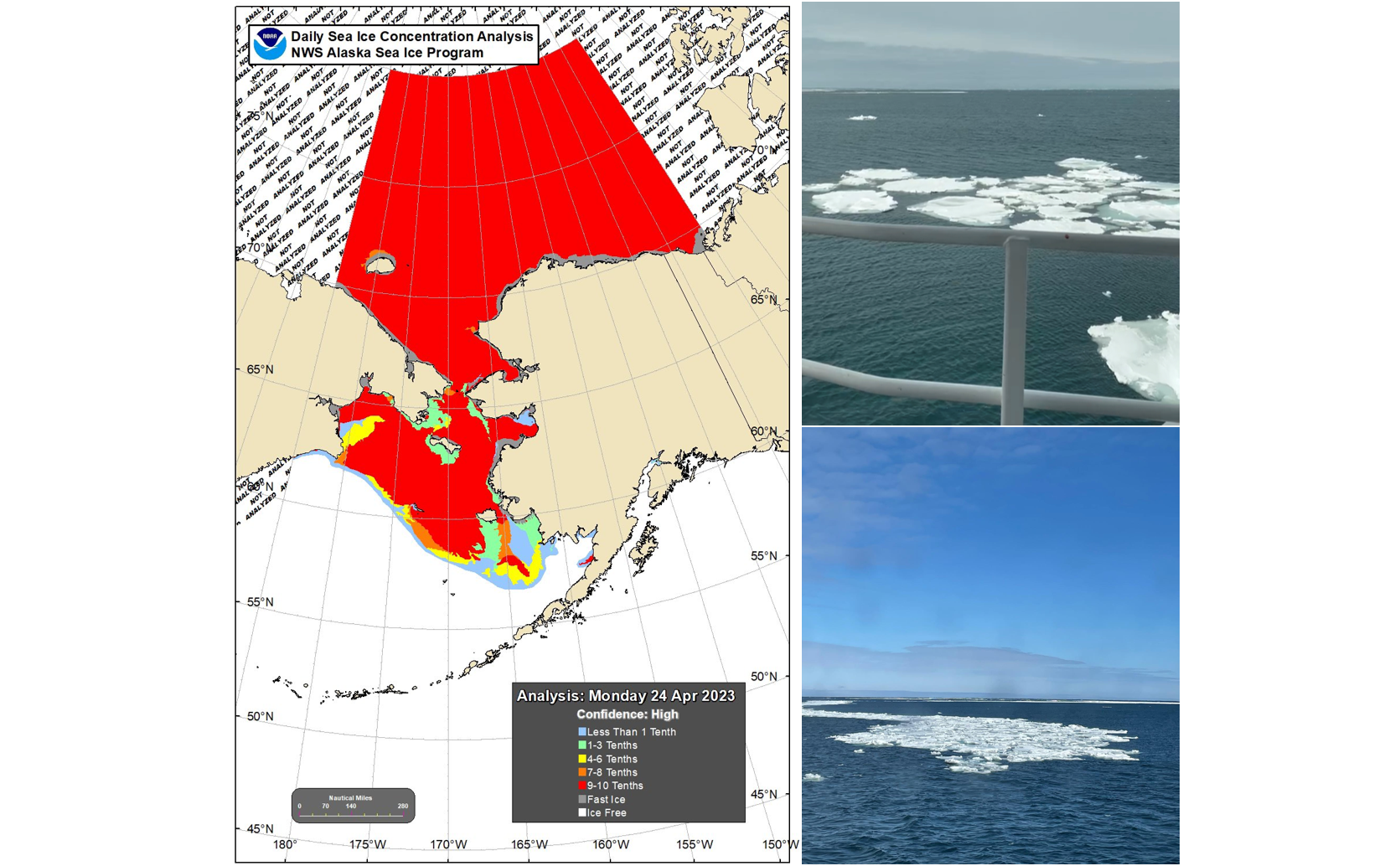
Annual Ecosystems & Fisheries-Oceanography Coordinated Investigations (EcoFOCI) Survey in the Bering Sea encounters sea ice (right images) for the first time since 2012. The map (left) shows sea ice extent in the region on April 24, 2023. Photo Credits: Shaun Bell
April 21 - May 8 - NOAA PMEL oceanographers and colleagues continue leading an annual effort to collect key data in understanding the Bering Sea. This important research cruise provides key insights to monitor events such as sea-ice loss and the cold pool in the region and how these are impacting the Arctic ecosystem. This year’s cruise started out a bit different!
For the first time since 2012, the ice extent in the Bering Sea is impacting the survey and researchers had to alter their cruise plan as the ice is at and around several of the mooring and sampling sites. While not thick ice, lead scientist and NOAA oceanographer Phyllis Stabeno was surprised. “I did not expect to see ice this late on the shelf,” she said. In this region, ice arrives in the Bering Sea in the fall and typically melts and recedes in spring, - limiting when research vessels can be in the area.
2012 was a record breaking year. The melt season of 2012 started out at a sluggish pace. Around mid-April, sea ice extent was close to the 1979–2000 average for that time of year (the maximum ice extent typically occurring in March). However, soon after that the decline began to accelerate rapidly.
Stabeno took this as a unique and unexpected opportunity to safely sample around the ice edge. Most vessels are not made to break ice - but they can go near this melting ice region. As the ice continues to melt, the science team will resume their planned research.
This spring mooring cruise brings together scientists from NOAA’s PMEL and Alaska Fisheries Science Center, the University of Washington, US Fish and Wildlife, and the University of Alaska. While aboard the NOAA Ship Oscar Dyson, the scientists will service a biophysical mooring array. They will also collect water samples of conductivity (salinity), temperature, depth (CTD) profiles, zooplankton, ichthyoplankton, nutrients and chlorophyll samples. As well as conduct collaborative research including on harmful algal blooms, omics, and zooplankton machine learning. Results from these observations and experiments will help describe important ecosystem linkages among climate, plankton, fishes, birds and mammals.
EcoFOCI will be field testing and using several innovations this spring. Innovations and technologies such as these aim to enhance shipboard and mooring research with advanced and increased data collection. These include the deployment of a modified ‘high-latitude’, more robust surface mooring at M2 and a shallow-water glider. This is the 29th consecutive year the M2 mooring will be deployed. In 2022 a combination of the pandemic, sea ice, and a storm provided researchers a new perspective from NOAA’s longest operating biophysical mooring site in the US Arctic. Learn more about that in a NOAA Story Map (https://storymaps.arcgis.com/stories/1b413464b13c4aa381b48ecd5c89ed50).
This is the first of five NOAA EcoFOCI program research cruises planned between April and October in the Alaska region.
Learn more about mooring arrays and the EcoFOCI spring cruise on NOAA Fisheries 2022 blog.
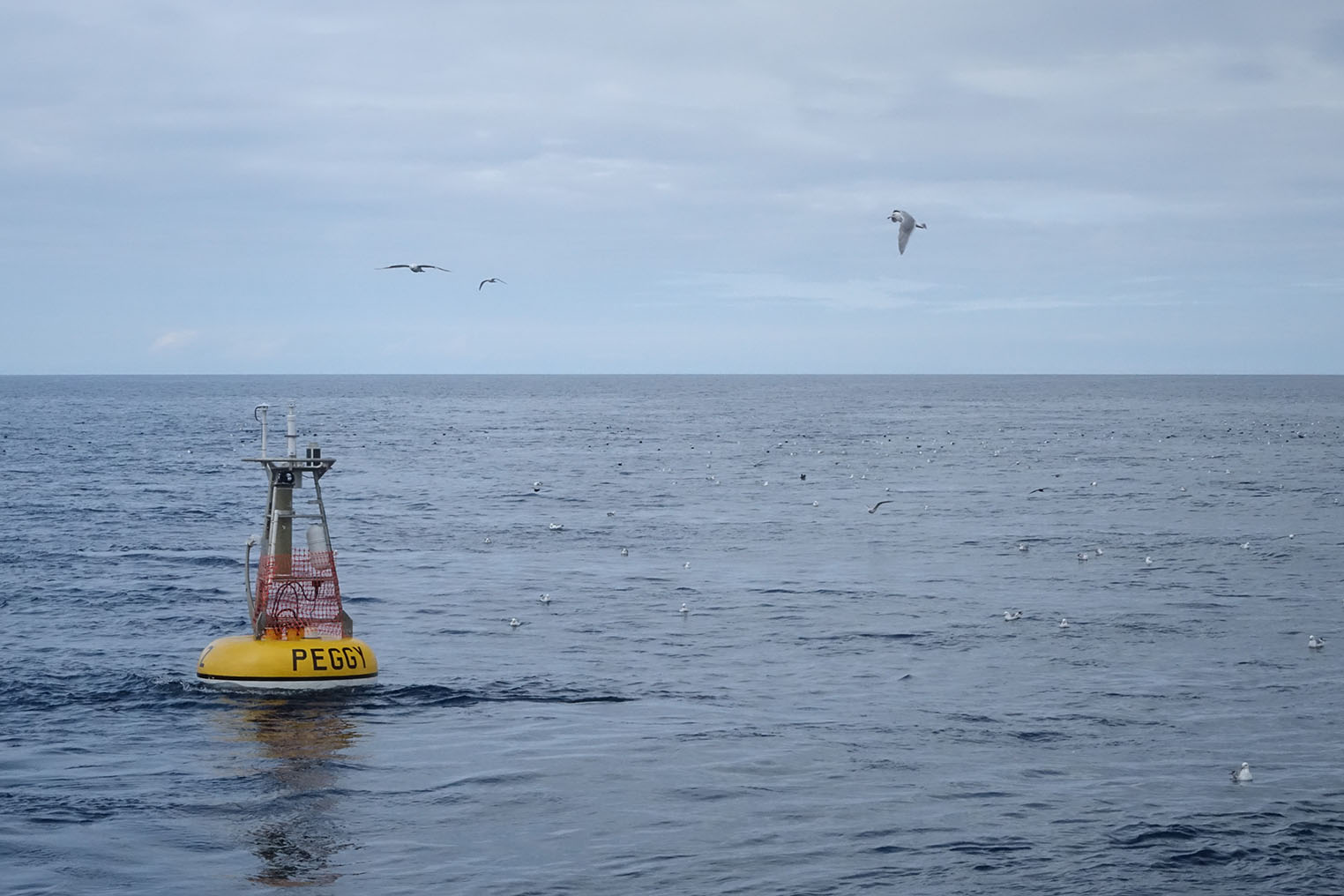
Peggy is a biophysical mooring nicknamed after Peggy Dyson being deployed in the Bering Sea. The biophysical mooring site 2 (M2) is one of the longest running time series of its kind providing near-continuous measurements since 1995 in the southeastern Bering Sea.
The Pivotal Recovery Story Map (ESRI) recounts the events in 2021 of how NOAA scientists raced against nature to save their most valuable scientific instruments in the Bering Sea. This interactive online map highlights the recovery efforts, the unique data collected and the implications it has for management.
In the fall of 2021, a combination of sea ice, hurricane-force winds, and a pandemic set the stage for what would become a momentous recovery effort for scientific moorings in the southeastern Bering Sea. These scientific moorings provide an overview of changing ocean conditions as part of a 30 year time series. Scientists deploy these moorings on an annual basis to ensure continuous measurements during ice and ice-free seasons.
NOAA scientists are at the forefront of detecting regional and global climate change and its impacts on Alaska’s marine ecosystems. With a generation of ocean observing, NOAA EcoFOCI, or the Ecosystems and Fisheries Oceanography Coordinated Investigations Program, continues to study and share how oceanographic and biological changes affect marine ecosystems such as the Cold Pool and impact of sea ice loss.
This Story Map was developed by Lindsey Neuwirth, a 2022 NOAA College Supported Intern at Stony Brook University.
To view the story map, please see this version on the ESRI website"Pivotal Recovery for Science''. Note that most story maps are large, single-page multimedia presentations. When using a mobile device, we recommend viewing over WiFi.
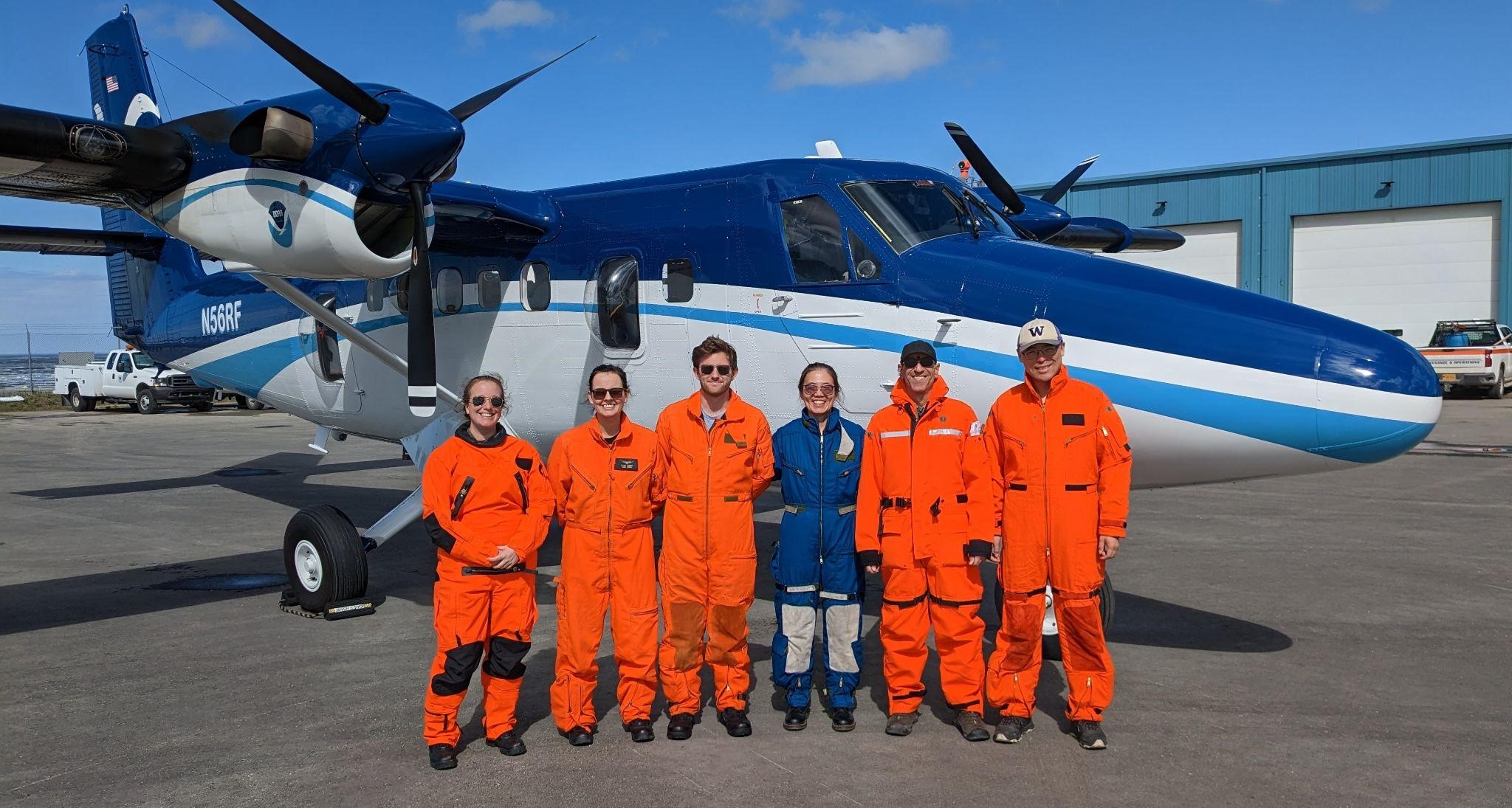
The team of NOAA and University of Washington Cooperative Institute scientists during the first flight mission over Alaskan waters to conduct renewed research on Arctic ocean heat flows.
July 29 - August 4: A team of NOAA and University of Washington Cooperative Institute scientists flew over Alaskan waters to conduct renewed research on Arctic ocean heat flows. Scientists deployed 30 floats from NOAA aircraft that will provide key temperature data to better understand how the Arctic ocean is warming.
The team completed the second leg of the 2022 mission from the northernmost point of Alaska, Utqiagvik. They deployed 24 temperature profilers, Airborne eXpendable Bathy Thermographs (AXBTs), in groups of six along four different sections of an ocean slope region. AXBTs are small probes that measure ocean temperature as a function of depth as they travel through the water column. The ocean floor contains a narrow channel where warm water flows into the Arctic, eventually splitting into two flows moving left and right. The goal of this research is to measure the water temperature along this slope and determine the total heat content that each pathway is guiding, including how much of that heat moves in each direction. Determining the heat flow (in both directions) provides important information that contributes to sea ice formation and retreat, as well as effects on downstream algal blooms.
In June, the team began the first flights from Prudhoe Bay to Kotzebue and deployed eight floats that measure ocean temperature to support data collection efforts of the Distributed Biological Observatory. The team deployed 8 AXBTs that will provide critical data in this undersampled area for the next few years. 2 of the 8 floats are transmitting ocean temperature data and measurements were collected between sampling locations.
This work is a fresh take on efforts established by the late Dr. Kevin Wood. Dr. Wood was deeply committed to understanding and communicating the nuances of science in a way that inspired and motivated people to work to mitigate climate change. To continue his legacy, special funding was brought together from NOAA PMEL, NOAA OMAO, and the University of Washington CICOES to support these flights.
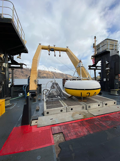
FOCI mooring ready for deployment in the Bering Sea aboard the NOAA Ship Oscar Dyson. The M2 surface mooring that has been deployed each spring in the southeastern Bering Sea for over 25 years. This critical mooring provides year-round measurements of temperature, salinity, nitrite, chlorophyll, and currents in this highly productive area. For the last 10 years, partial pressure in CO2 (pCO2) and pH measurements have also been taken at M2.
An annual survey is underway to provide baseline fisheries and oceanographic data to support sustainable management of living resources in the Bering Sea and the rapidly changing US Arctic ecosystem. These surveys provide key data in understanding and monitoring events such as sea-ice loss and the cold pool and how these are impacting the Arctic ecosystem.
This spring mooring cruise brings together scientists from NOAA’s PMEL and Alaska Fisheries Science Center, University of Washington, US Fish and Wildlife, and the University of Alaska. While aboard the NOAA Ship Oscar Dyson, the scientists will service a biophysical mooring array in the Bering Sea, collect conductivity, temperature, depth (CTD) profiles, zooplankton and ichthyoplankton samples and conduct special projects related to harmful algal blooms and zooplankton machine learning. Results from these observations and experiments will help describe important ecosystem linkages among climate, plankton, fishes, birds and mammals.
EcoFOCI will be field testing and using several technologies this summer, including pop-up floats, a remote access sampler and a new shallow-water glider. These technologies aim to enhance shipboard and mooring research with more data collection in a fine scale region.
NOAA’s EcoFOCI program is leading 5 research cruises this March to October in the Alaska region.
Find blog updates on the NOAA Alaska Fisheries Science Center webpage: https://www.fisheries.noaa.gov/region/alaska#science
FOCI mooring ready for deployment in the Bering Sea aboard the NOAA Ship Oscar Dyson. The M2 surface mooring that has been deployed each spring in the southeastern Bering Sea for over 25 years. This critical mooring provides year-round measurements of temperature, salinity, nitrite, chlorophyll, and currents in this highly productive area. For the last 10 years, partial pressure in CO2 (pCO2) and pH measurements have also been taken at M2.
An annual survey is underway to provide baseline fisheries and oceanographic data to support sustainable management of living resources in the Bering Sea and the rapidly changing US Arctic ecosystem. These surveys provide key data in understanding and monitoring events such as sea-ice loss and the cold pool and how these are impacting the Arctic ecosystem.
This spring mooring cruise brings together scientists from NOAA’s PMEL and Alaska Fisheries Science Center, University of Washington, US Fish and Wildlife, and the University of Alaska. While aboard the NOAA Ship Oscar Dyson, the scientists will service a biophysical mooring array in the Bering Sea, collect conductivity, temperature, depth (CTD) profiles, zooplankton and ichthyoplankton samples and conduct special projects related to harmful algal blooms and zooplankton machine learning. Results from these observations and experiments will help describe important ecosystem linkages among climate, plankton, fishes, birds and mammals.
EcoFOCI will be field testing and using several technologies this summer, including pop-up floats, a remote access sampler and a new shallow-water glider. These technologies aim to enhance shipboard and mooring research with more data collection in a fine scale region.
NOAA’s EcoFOCI program is leading 5 research cruises this March to October in the Alaska region.
Zone map for the 2022 Pan-Pacific Winter High Seas Expedition(click on image to see the full map).Credit: NOAA Fisheries
NOAA Ship Shimada leaving Port Angeles, Washington to join the Year of the Salmon Expedition. Photo Credit: CDR Duncan/NOAA
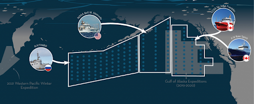
February 1 - March 7: NOAA PMEL scientists join NOAA Fisheries and an international team of researchers aboard the NOAA R/V Shimada to provide expertise in physical oceanography and lead hydrographic data collection, nutrient sampling, analysis and processing. EcoFOCI is taking part in the International Year of the Salmon expedition to help detect and monitor changes both within Pacific salmon and their respective ecosystems, especially in the Gulf of Alaska.
Pacific salmon are a uniquely important resource for countries across the North Pacific yet there are major scientific gaps in our understanding of the ocean phase of the salmon life cycle. This cruise will collect vital data to improve that understanding and aid in forecasting and management of salmon.
The expedition will include as many as five research vessels to conduct the largest ever pan-Pacific, epipelagic ecosystem survey during winter, focused on understanding salmon and their ecosystems. The 2022 Expedition will involve a full ecosystem survey with pelagic trawling and detailed sampling of marine life in the upper ocean and will include research on physical, biological and chemical oceanography. Novel technologies such as gliders, environmental DNA and genetic stock identification will be used to enhance research efforts. This collaborative international effort spanning the entire North Pacific includes scientists from Canada, Japan, the Republic of Korea, the Russian Federation, and the United States.
The data collected by PMEL will provide key baseline and comparative data to the overall pan-Pacific collaboration focused on salmon recovery. During the expedition, PMEL will collect samples from over 30 CTD stations, deploy satellite-tracked drifters and several Argo floats, and collect carbon dioxide, nutrient and salinity measurements from an on-board flow-through system.
The research cruise will extend from 1 February to 7 March in the central to western Gulf of Alaska. More about the expedition: https://yearofthesalmon.org/2022expedition/
Follow along with the expedition on the blog and more details online: https://www.fisheries.noaa.gov/west-coast/2022-pan-pacific-winter-high-seas-expedition
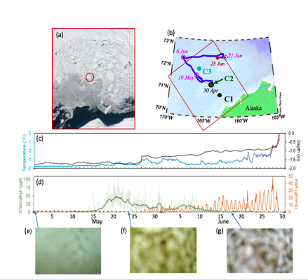
During the first Chukchi deployment, floats resurfaced under a sheet of floating ice (ice floe), monitored and tracked the ice region for almost two months and detected an under-ice algae bloom (Stabeno et. al, 2020). The bottom row shows the captured images with no bloom and/or algae.
After spending 8 months under water and ice, two of NOAA’s three Arctic-deployed pop-up floats have successfully surfaced in the Chukchi Sea and are transmitting data on temperature, pressure, photosynthetic active radiation (PAR), and chlorophyll fluorescence. These data are from measurements taken while the float is anchored to the seafloor, while it rises through the water column, and while it is trapped under the ice at the water-ice boundary.
The two floats were initially deployed in the fall of 2020 by the scientists and crew of NOAA Ship Oscar Dyson. These are part of the 4th cohort of deployments since 2017, and the second cohort deployed in the Chukchi Sea. The first float to surface has transmitted data from the four months it spent on the seafloor, just over a month of data from when it was trapped under ice, and about half of the photos it took while under ice. The second float has transmitted about five months of data from the seafloor, just over four months of data from under the ice along with the under-ice photos it captured, and 7 days of open ocean sea surface temperature.
Pop-up floats provide an inexpensive method to explore a unique micro-ecosystem under floating ice. The floats collect ocean health data to help researchers better understand the rapidly changing Arctic ecosystem. They collect data during the ice-covered winter and spring months, a time during which it isn’t possible for researchers to penetrate the ice from above to study the water underneath. The water column data they collect on their rise up from seafloor to surface is essential for researchers to monitor ongoing ecosystem changes in the Arctic, such as watching for harmful algal blooms and documenting biodiversity in the environment. The floats can also help researchers measure the extent of the cold pool, an area of cold water about 30 meters deep that results from melting Arctic ice from the previous season.
NOAA PMEL began development of these floats in 2015. The float is an orange sphere equipped with sensors to measure temperature, pressure, and other ocean conditions as well as cameras to capture under ice imagery. It is deployed during the ice-free summer months and anchors to the seafloor measuring bottom-ocean conditions. It stays here collecting measurements throughout the winter and early spring. It then rises up through the water column at a pre-programmed time, in this case early March to mid-April, capturing data at various depths to create a profile of the water column. The floats are then trapped under ice when it reaches the surface, and will continue collecting data and images of conditions at the water-ice boundary. When the ice melts in mid-May and early June, the floats can emerge fully from the ice to reach the surface and begin transmitting their stored data, while continuing to monitor sea surface temperature.
Read more about the 2020 pop-up deployments in Arctic Today and on the ITAE website.

These moorings will be deployed in the Bering Sea as part of an array that collects near-continuous, year-round measurements to better understand the mechanisms and changes in a highly productive ecosystem to support sustainable management of living marine resources.
he EcoFOCI spring mooring cruise departed on the NOAA Ship Oscar Dyson on May 1, from Kodiak, AK for an annual survey that was missed in 2020 due to the COVID-19 pandemic. Scientists from NOAA’s PMEL, University of Washington Cooperative Institute for Climate, Ocean and Ecosystem Studies (CICOES) and NOAA’s Alaska Fisheries Science Center will service a biophysical mooring array in the Bering Sea, collect conductivity, temperautre, depth (CTD) profiles, zooplankton and ichthyoplankton samples and conduct special projects related to harmful algal blooms and zooplankton machine learning. Results from these observations and experiments will help describe important ecosystem linkages among climate, plankton, fishes, birds and mammals. Continuous monitoring in this region provides critical data to support sustainable management of living resources in the Bering Sea and the rapidly changing US Arctic ecosystem.
The M2 surface mooring has been deployed each spring in the southeastern Bering Sea for over 25 years and provides year-round measurements of temperature, salinity, nitrite, chlorophyll, and currents in this highly productive area. Carbon dioxide measurements taken from M2 reached another milestone of 10 years collecting data. Long-term time-series at this site are a critical tool for adapting to climate change and guiding sustainable management of living resources in the Bering Sea.
EcoFOCI will also be field testing and using several technologies in collaboration with the Innovative Technology for Arctic Exploration program including pop-up floats and remote access sampler. These technologies enhance shipboard and mooring research with more data collection over a fine scale region.
This is one of 5 research cruises the program will either lead or participate in from March-October. Geoff Lebon from UW CICOES is the Chief Scientist on the cruise. The EcoFOCI program is a collaborative research effort by scientists at NOAA's Pacific Marine Environmental Laboratory (PMEL) and Alaska Fisheries Science Center (AFSC) focusing on the unique and economically important high-latitude ecosystems of Alaska.